



Picture the week after a big engagement survey closes. Thousands of responses are in — comments, ratings, and pins dropped all over a map of the neighborhood. Somewhere on a planning team, someone opens a blank document and starts reading, tagging, and geolocating by hand. It takes days.
That (not-so-great) process is what we spent the summer rebuilding, and AI has been a big part of it.
Now, we're writing this in 2026 and everyone is adding AI to community engagement software right now. But almost none of it knows about location. That's the gap we've been closing — and we didn't just add a chatbot, we built a location-aware AI that does the busy work for you, from the blank page to the client-ready report. Here's what that means in practice.
Describe your survey and AI drafts it
Type what you need — a corridor safety study, feedback on a park redesign, early visioning ideas for a comprehensive plan — or paste in questions you already have. AI hands you a ready-to-edit survey, map elements and all, in seconds flat. No blank page, no manual setup. What used to take an afternoon now takes less time than for your coffee to get cold.
A mobility preference survey, drafted from a couple sentences.
AI thoroughness + human judgement
This is the one that changes the math for a planning team. Point AI at your results and it clusters and tags every open-ended response, groups the map responses into patterns by location (not just by keyword) and assembles a polished report with maps, charts, and narrative already written. You review, adjust, and iterate; you don't build from a blank canvas.
Because the data was spatial from the moment it was collected, the clustering isn't vague: “mostly positive, some concerns”. It's specific: “concentrated opposition three blocks north of the site entrance.” Nobody else's AI can say that sentence, because nobody else's data has “where” baked in.
The “three blocks north” isn't the AI guessing. The cluster and its statistical significance are computed mathematically. The AI only writes the sentence that describes what the numbers already show.
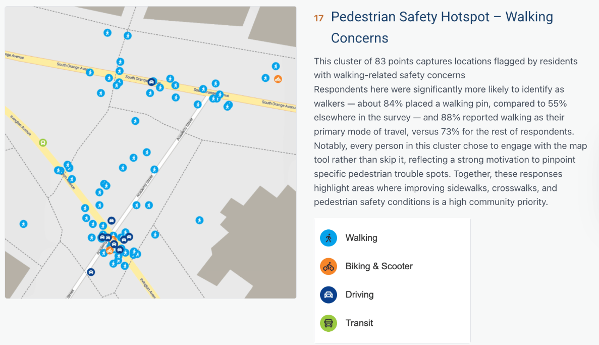
What took your team days of manual tagging and chart-building now process in a couple minutes.
AI analysis you can defend
The obvious worry with AI on public input is whether you can trust it. Here's why you can. The AI doesn't summarize your raw responses, because language models aren't reliable with that yet. Instead, it codes responses the way a researcher would: it proposes a small set of recurring themes, tags every answer against them one at a time, then writes the narrative from the tag counts and real, verbatim example quotes. Community responses are never paraphrased or invented.
The map clusters are computed mathematically; the AI only describes what the numbers already show. Every theme is yours to edit or replace, every step is visible, and anyone can retrace how a finding was reached. It follows the 2026 AAPOR guidance for AI-assisted coding of open-ended survey responses. We walk through exactly how that works — filtering by topic, place, and respondent, then building a defensible audit trail — in How to Turn Thousands of Map Pins Into Defensible Findings in Minutes with AI.
You review and adjust — you don't build from a blank canvas.
Export to ChatGPT, Claude, or Gemini — map and all
One export, structured for ChatGPT, Claude, or Gemini. Spatial context is intact, not stripped out. Go deeper without rebuilding your dataset by hand.
Translate into 50+ languages, and ask AI about your results
AI also translates your surveys and project pages into 50+ languages, and you can ask it questions about your results directly.
Unlimited surveys on every plan
Every plan, including the entry tier, now comes with unlimited surveys and full AI analysis built in, not gated behind a higher tier. When drafting takes a minute and analysis takes a coffee break, a survey limit is the last thing that should slow your team down. So we removed it.
Why flat-data tools can't do this
None of this works for a tool that collects flat, nonspatial data. You can bolt a chatbot onto a spreadsheet, but it will never tell you what the west side of the neighborhood thinks versus the east side, because it never captured “west side” as data in the first place.
That's not a feature gap a model upgrade can close, it's a data-model problem. But not a problem we have.
What that difference looks like:
And spatial data on its own isn't the answer either. Point a chatbot at even the richest map dataset and you'll get confident-sounding guesses and unreliable cherry-picking, just with coordinates attached.
What makes the difference is the guardrails: AI that codes methodically instead of summarizing, and runs on data that includes location. Neither half works alone.
Fifteen years of knowing ‘where’
We didn't just make a new AI tool out of the blue, we added it to our fifteen years of mapping expertise. Since 2011, Maptionnaire has carried 25 million community members and more than 15,000 planning projects across 40+ countries. The AI is new; the ground it stands on isn't.
Where this goes next
What becomes possible when an AI can reason through data that includes the “where”? How will you plan differently when you you have more than the overall sentiment, when you know specifically how different groups feel about different locations?
The implications for equitable planning are huge.
We spent this summer on the groundwork: powerful tools for survey drafting, analysis, data export. But the more interesting work is what you — the planners — will do with it.
In short
- The AI drafts your survey from a sentence and writes your results report for you. The busywork at both ends is gone.
- The difference from every other AI: ours knows where. Findings belong to a place (“hotspot on 4th St and Main”) and aren't just a vague idea.
- And they hold up: the clusters are real math, the quotes are verbatim, every step is traceable.
- Part of the trusted and proven platform that's served 25M community members and 15,000+ projects across 40+ countries in fifteen years.
- No quota holding it back: unlimited surveys, full AI toolkit, every plan.
.png)

.png)
%20(1).png)




.png)

.webp)


.webp)

-min.webp)
.webp)
.webp)


.webp)


.webp)


.webp)


.webp)
.webp)
.webp)


.webp)


